 국립중앙도서관 "우편 복사 서비스"로 연결 됩니다.

 ScienceON
In general, RGB, NIR, and thermal images are used for obtaining geospatial data. Such multiband images are collected via devices mounted on satellites or manned flights, but do not always meet users' expectations, due to issues associated with tempora...
다국어 입력
あ
ぁ
か
が
さ
ざ
た
だ
な
は
ば
ぱ
ま
や
ゃ
ら
わ
ゎ
ん
い
ぃ
き
ぎ
し
じ
ち
ぢ
に
ひ
び
ぴ
み
り
う
ぅ
く
ぐ
す
ず
つ
づ
っ
ぬ
ふ
ぶ
ぷ
む
ゆ
ゅ
る
え
ぇ
け
げ
せ
ぜ
て
で
ね
へ
べ
ぺ
め
れ
お
ぉ
こ
ご
そ
ぞ
と
ど
の
ほ
ぼ
ぽ
も
よ
ょ
ろ
を
ア
ァ
カ
サ
ザ
タ
ダ
ナ
ハ
バ
パ
マ
ヤ
ャ
ラ
ワ
ヮ
ン
イ
ィ
キ
ギ
シ
ジ
チ
ヂ
ニ
ヒ
ビ
ピ
ミ
リ
ウ
ゥ
ク
グ
ス
ズ
ツ
ヅ
ッ
ヌ
フ
ブ
プ
ム
ユ
ュ
ル
エ
ェ
ケ
ゲ
セ
ゼ
テ
デ
ヘ
ベ
ペ
メ
レ
オ
ォ
コ
ゴ
ソ
ゾ
ト
ド
ノ
ホ
ボ
ポ
モ
ヨ
ョ
ロ
ヲ
―
http://chineseinput.net/에서 pinyin(병음)방식으로 중국어를 변환할 수 있습니다.
변환된 중국어를 복사하여 사용하시면 됩니다.
예시)
- 中文 을 입력하시려면 zhongwen을 입력하시고 space를누르시면됩니다.
- 北京 을 입력하시려면 beijing을 입력하시고 space를 누르시면 됩니다.
А
Б
В
Г
Д
Е
Ё
Ж
З
И
Й
К
Л
М
Н
О
П
Р
С
Т
У
Ф
Х
Ц
Ч
Ш
Щ
Ъ
Ы
Ь
Э
Ю
Я
а
б
в
г
д
е
ё
ж
з
и
й
к
л
м
н
о
п
р
с
т
у
ф
х
ц
ч
ш
щ
ъ
ы
ь
э
ю
я
′
″
℃
Å
¢
£
¥
¤
℉
‰
$
%
F
₩
㎕
㎖
㎗
ℓ
㎘
㏄
㎣
㎤
㎥
㎦
㎙
㎚
㎛
㎜
㎝
㎞
㎟
㎠
㎡
㎢
㏊
㎍
㎎
㎏
㏏
㎈
㎉
㏈
㎧
㎨
㎰
㎱
㎲
㎳
㎴
㎵
㎶
㎷
㎸
㎹
㎀
㎁
㎂
㎃
㎄
㎺
㎻
㎽
㎾
㎿
㎐
㎑
㎒
㎓
㎔
Ω
㏀
㏁
㎊
㎋
㎌
㏖
㏅
㎭
㎮
㎯
㏛
㎩
㎪
㎫
㎬
㏝
㏐
㏓
㏃
㏉
㏜
㏆

RISS 인기검색어

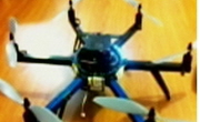
마이크로 UAV 다중영상센서 페이로드개발과 정사영상제작 = The Development of a Multi-sensor Payload for a Micro UAV and Generation of Ortho-images
한글로보기https://www.riss.kr/link?id=A101662636
-
저자
한승희 (공주대학교) ; Han, Seung Hee

- 발행기관
- 학술지명
- 권호사항
-
발행연도
2014
-
작성언어
Korean
- 주제어
-
등재정보
KCI등재
-
자료형태
학술저널
- 발행기관 URL
-
수록면
1645-1653(9쪽)
-
KCI 피인용횟수
1
- DOI식별코드
- 제공처
- 소장기관
-
0
상세조회 -
0
다운로드
부가정보
다국어 초록 (Multilingual Abstract)
In general, RGB, NIR, and thermal images are used for obtaining geospatial data. Such multiband images are collected via devices mounted on satellites or manned flights, but do not always meet users' expectations, due to issues associated with temporal resolution, costs, spatial resolution, and effects of clouds. We believe high-resolution, multiband images can be obtained at desired time points and intervals, by developing a payload suitable for a low-altitude, auto-piloted UAV. To achieve this, this study first established a low-cost, high-resolution multiband image collection system through developing a sensor and a payload, and collected geo-referencing data, as well as RGB, NIR and thermal images by using the system. We were able to obtain a 0.181m horizontal deviation and 0.203m vertical deviation, after analyzing the positional accuracy of points based on ortho mosaic images using the collected RGB images. Since this meets the required level of spatial accuracy that allows production of maps at a scale of 1:1,000~5,000 and also remote sensing over small areas, we successfully validated that the payload was highly utilizable.
국문 초록 (Abstract)
대부분의 지형정보획득을 위한 영상에는 RGB, 근적외선, 열영상이 주로 사용된다. 이 멀티밴드영상은 위성이나 유인항공기에 탑재되어 획득되고 있으나 주기해상도, 비용, 공간해상도, 그리...
대부분의 지형정보획득을 위한 영상에는 RGB, 근적외선, 열영상이 주로 사용된다. 이 멀티밴드영상은 위성이나 유인항공기에 탑재되어 획득되고 있으나 주기해상도, 비용, 공간해상도, 그리고 구름의 영향 등으로 사용자를 만족시키기 어렵다. 자동항법UAV에 적합한 페이로드와 콘트롤러를 개발한다면 원하는 시간과 주기로 고해상도 멀티밴드영상을 획득할 수 있다. 본 연구에서는 멀티밴드 영상획득을 위한 센서와 페이로드의 개발을 통해 저가의 고해상 영상획득시스템을 구축하고 이를 이용하여 geo-referencing data와 함께 RGB, NIR과 열영상을 획득하였다. 획득한 RGB영상으로 정사모자익영상을 제작하여 검사점에 대한 위치정확도를 분석한 결과 수평좌표에서 0.181m, 수직좌표에서 0.203m의 편차를 얻을 수 있었다. 이는 1:1,000~5000수치지도제작과 소규모지역에 대한 원격탐측이 가능한 공간정확도를 만족하므로 페이로드의 활용성을 검증할 수 있었으며 활용이 기대된다.
참고문헌 (Reference)
1 Austin, M. J., "gRAID: A geospatial real-time aerial image display for a low-cost autonomous multispectral remote sensing" Utah State University 2009
2 NASA, "World wind software"
3 "World Wind Java SDK 2.0"
4 "UVS International"
5 Eck, C., "Navigation algorithms with applications to unmanned helicopters" Swiss federal institute of technology Zurich 2001
6 Hu, S. G., "Low-Cost UAV-Based thermal infrared remote sensing: Platform, Calibration and applications" 38-43, 2010
7 Baumann, M., "Imager development and image processing for small UAV-based realtime multispectral remote sensing" University of Applied Sciences Ravensburg- Weingarten and Utah State University 2007
8 "GPHOTO"
9 Echard, P., "Data & Image fusion for multisensor UAV payload" RTO 2005
10 Chao, H. Y., "Cooperative remote sensing and actuation using network unmanned vehicles" Utah state University 2010
11 Przybilla, H. J., "Bildflug mit ferngelenktem kleinflugzeug. Bildmessung und luftbildwesen. Zeitschrift fuer photogrammetrie und fernerkundung" Herbert Wichman Verlag 1979
12 HaiYang Chao, "Autopilots for Small Unmanned Aerial Vehicles: A Survey" 제어·로봇·시스템학회 8 (8): 36-44, 2010
13 Han, Y., "An autonomous unmanned aerial vehicle-based imagery system development and remote sensing images classification for agricultural applications" Utah State Univeristy 2009
14 Wester-Ebbinghaus, W., "Aerial photography by radio controlled model helicopter" 10 (10): 1980
15 Henri, E., "A mini unmanned aerial vehicle (UAV): System overview and image acquisition" 18-20, 2004
16 Han, S. H., "A design proposal for economical autopiloted UAVs for acquiring geospatial information(II)" 183-186, 2014
17 Han, S. H., "A design proposal for economical autopiloted UAVs for acquiring geospatial information(I)" 138-139, 2013
동일학술지(권/호) 다른 논문
-
레이더 강우 및 분포형 수문모형의 공간해상도가 매개변수 추정에 미치는 영향 평가
- 대한토목학회
- 노성진
- 2014
- KCI등재
-
LES를 이용한 직사각형 개수로 난류흐름의 조직구조 분석
- 대한토목학회
- 반채웅
- 2014
- KCI등재
-
- 대한토목학회
- 유인상
- 2014
- KCI등재
-
지하수위 변동 해석모델을 이용한 제주지역의 수리지질 매개변수 민감도 분석
- 대한토목학회
- 김남원
- 2014
- KCI등재
분석정보
인용정보 인용지수 설명보기
학술지 이력
| 연월일 | 이력구분 | 이력상세 | 등재구분 |
|---|---|---|---|
| 2022 | 평가예정 | 계속평가 신청대상 (등재유지) | |
| 2017-01-01 | 평가 | 우수등재학술지 선정 (계속평가) | |
| 2013-01-01 | 평가 | 등재학술지 유지 (등재유지) | |
| 2010-01-01 | 평가 | 등재학술지 유지 (등재유지) | |
| 2008-01-01 | 평가 | 등재학술지 유지 (등재유지) | |
| 2006-01-01 | 평가 | 등재학술지 유지 (등재유지) | |
| 2004-01-01 | 평가 | 등재학술지 유지 (등재유지) | |
| 2001-07-01 | 평가 | 등재학술지 선정 (등재후보2차) | |
| 1998-07-01 | 평가 | 등재후보학술지 선정 (신규평가) |  |
학술지 인용정보
| 기준연도 | WOS-KCI 통합IF(2년) | KCIF(2년) | KCIF(3년) |
|---|---|---|---|
| 2016 | 0.4 | 0.4 | 0.41 |
| KCIF(4년) | KCIF(5년) | 중심성지수(3년) | 즉시성지수 |
| 0.38 | 0.35 | 0.707 | 0.11 |
연관 공개강의(KOCW)
이 자료와 함께 이용한 RISS 자료
나만을 위한 추천자료


