 국립중앙도서관 "우편 복사 서비스"로 연결 됩니다.

 DBpia
DBpia
A group of forts over Mt. Acha area is representative of ruins of Goruryeo in the Basin of Han River basin, and 17 forts of them are designated as Historic Site No. 455 and taken care of. However, due to the relatively short period of occupancy by Gor...
다국어 입력
あ
ぁ
か
が
さ
ざ
た
だ
な
は
ば
ぱ
ま
や
ゃ
ら
わ
ゎ
ん
い
ぃ
き
ぎ
し
じ
ち
ぢ
に
ひ
び
ぴ
み
り
う
ぅ
く
ぐ
す
ず
つ
づ
っ
ぬ
ふ
ぶ
ぷ
む
ゆ
ゅ
る
え
ぇ
け
げ
せ
ぜ
て
で
ね
へ
べ
ぺ
め
れ
お
ぉ
こ
ご
そ
ぞ
と
ど
の
ほ
ぼ
ぽ
も
よ
ょ
ろ
を
ア
ァ
カ
サ
ザ
タ
ダ
ナ
ハ
バ
パ
マ
ヤ
ャ
ラ
ワ
ヮ
ン
イ
ィ
キ
ギ
シ
ジ
チ
ヂ
ニ
ヒ
ビ
ピ
ミ
リ
ウ
ゥ
ク
グ
ス
ズ
ツ
ヅ
ッ
ヌ
フ
ブ
プ
ム
ユ
ュ
ル
エ
ェ
ケ
ゲ
セ
ゼ
テ
デ
ヘ
ベ
ペ
メ
レ
オ
ォ
コ
ゴ
ソ
ゾ
ト
ド
ノ
ホ
ボ
ポ
モ
ヨ
ョ
ロ
ヲ
―
http://chineseinput.net/에서 pinyin(병음)방식으로 중국어를 변환할 수 있습니다.
변환된 중국어를 복사하여 사용하시면 됩니다.
예시)
- 中文 을 입력하시려면 zhongwen을 입력하시고 space를누르시면됩니다.
- 北京 을 입력하시려면 beijing을 입력하시고 space를 누르시면 됩니다.
А
Б
В
Г
Д
Е
Ё
Ж
З
И
Й
К
Л
М
Н
О
П
Р
С
Т
У
Ф
Х
Ц
Ч
Ш
Щ
Ъ
Ы
Ь
Э
Ю
Я
а
б
в
г
д
е
ё
ж
з
и
й
к
л
м
н
о
п
р
с
т
у
ф
х
ц
ч
ш
щ
ъ
ы
ь
э
ю
я
′
″
℃
Å
¢
£
¥
¤
℉
‰
$
%
F
₩
㎕
㎖
㎗
ℓ
㎘
㏄
㎣
㎤
㎥
㎦
㎙
㎚
㎛
㎜
㎝
㎞
㎟
㎠
㎡
㎢
㏊
㎍
㎎
㎏
㏏
㎈
㎉
㏈
㎧
㎨
㎰
㎱
㎲
㎳
㎴
㎵
㎶
㎷
㎸
㎹
㎀
㎁
㎂
㎃
㎄
㎺
㎻
㎽
㎾
㎿
㎐
㎑
㎒
㎓
㎔
Ω
㏀
㏁
㎊
㎋
㎌
㏖
㏅
㎭
㎮
㎯
㏛
㎩
㎪
㎫
㎬
㏝
㏐
㏓
㏃
㏉
㏜
㏆

RISS 인기검색어

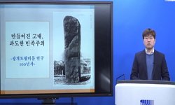
한강유역 고구려 보루의 축조방식과 성격 = Construction Method and Characteristics of Goguryeo Forts in the Basin of Han river
한글로보기https://www.riss.kr/link?id=A106448841
-
저자
이정범 (한국고고환경연구소)
- 발행기관
- 학술지명
- 권호사항
-
발행연도
2019
-
작성언어
Korean
-
주제어
고구려 ; 관방시설 ; 산성 ; 보루 ; 보루군 ; 한강유역 ; 아차산 ; 축조방식 ; Goguryeo ; Military facilities ; Mountain fortress ; Fort ; Hangang River ; Mt. Acha ; Construction Method
-
등재정보
KCI등재
-
자료형태
학술저널
-
수록면
201-232(32쪽)
-
KCI 피인용횟수
0
- DOI식별코드
- 제공처
- 소장기관
-
0
상세조회 -
0
다운로드
부가정보
다국어 초록 (Multilingual Abstract)
A group of forts over Mt. Acha area is representative of ruins of Goruryeo in the Basin of Han River basin, and 17 forts of them are designated as Historic Site No. 455 and taken care of. However, due to the relatively short period of occupancy by Goruryeo and geopolitical features that the royal castle of Baekje was located in that area, in the past, it was recognized as defense outpost remains related to Baekje, and the interest for the ruins was considerably low.
The earliest record of fortress over Mt. Acha is seen in Daedongjiji, which was published geographical book in the late Joseon Dynasty under the name of Mt. Acha old fortress. Meanwhile the full-scale record had been done during the Japanese occupation period. Although relatively detailed locations of the sites were recorded at that time, it was kept as internal data of the Joseon governor general office and not disclosed to the general. As a result, the data have not been widely used for research after liberation. However, in the 80's, as the existence of Goguryeo earthenware was confirmed in Mongchontoseong and the previously investigated sites of Guui-dong were reconsidered as Goguryeo fortress, the existence of Goguryeo sites was newly recognized in the Han River basin.
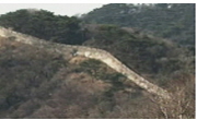
Since the academic research starting in 1994, the successful results of the extensive excavation on the walls and internal facilities of various forts have been added, and various studies on the structure and characteristics of the Goguryeo forts have been conducted. The most remarkable characteristic of the Goguryeo forts in South Korea is that they were mostly small scale structures with a circumference of more or less 300 meters on the top of mountains, except for the fortress built on some plains, and they had the facilities such as building areas and reservoirs on the flatland surrounded by stone walls along the top of mountains. Most of the walls are divided into soil and stone parts, which is typical of Goguryeo's forts construction as seen in Gooknae fortress and Jnangsoo fortress. Meanwhile, there have been various opinions regarding the construction method so far. In this regard, further excavation and research should be carried out. In addition, it is generally accepted that Goguryeo had occupied Hangang river basin until the mid-sixth century. However, some researchers believe the occupancy period can be extended to the early seventh century. As well as the basic functions as a defense facility, the forts seem to have performed as a 'Government office'. . Although it was thwarted by Silla and Baekje, it seems that Goguryeo intended to dominate the area as a territory.
The earliest record of fortress over Mt. Acha is seen in Daedongjiji, which was published geographical book in the late Joseon Dynasty under the name of Mt. Acha old fortress. Meanwhile the full-scale record had been done during the Japanese occupation period. Although relatively detailed locations of the sites were recorded at that time, it was kept as internal data of the Joseon governor general office and not disclosed to the general. As a result, the data have not been widely used for research after liberation. However, in the 80's, as the existence of Goguryeo earthenware was confirmed in Mongchontoseong and the previously investigated sites of Guui-dong were reconsidered as Goguryeo fortress, the existence of Goguryeo sites was newly recognized in the Han River basin.
Since the academic research starting in 1994, the successful results of the extensive excavation on the walls and internal facilities of various forts have been added, and various studies on the structure and characteristics of the Goguryeo forts have been conducted. The most remarkable characteristic of the Goguryeo forts in South Korea is that they were mostly small scale structures with a circumference of more or less 300 meters on the top of mountains, except for the fortress built on some plains, and they had the facilities such as building areas and reservoirs on the flatland surrounded by stone walls along the top of mountains. Most of the walls are divided into soil and stone parts, which is typical of Goguryeo's forts construction as seen in Gooknae fortress and Jnangsoo fortress. Meanwhile, there have been various opinions regarding the construction method so far. In this regard, further excavation and research should be carried out. In addition, it is generally accepted that Goguryeo had occupied Hangang river basin until the mid-sixth century. However, some researchers believe the occupancy period can be extended to the early seventh century. As well as the basic functions as a defense facility, the forts seem to have performed as a 'Government office'. . Although it was thwarted by Silla and Baekje, it seems that Goguryeo intended to dominate the area as a territory.
A group of forts over Mt. Acha area is representative of ruins of Goruryeo in the Basin of Han River basin, and 17 forts of them are designated as Historic Site No. 455 and taken care of. However, due to the relatively short period of occupancy by Goruryeo and geopolitical features that the royal castle of Baekje was located in that area, in the past, it was recognized as defense outpost remains related to Baekje, and the interest for the ruins was considerably low.
The earliest record of fortress over Mt. Acha is seen in Daedongjiji, which was published geographical book in the late Joseon Dynasty under the name of Mt. Acha old fortress. Meanwhile the full-scale record had been done during the Japanese occupation period. Although relatively detailed locations of the sites were recorded at that time, it was kept as internal data of the Joseon governor general office and not disclosed to the general. As a result, the data have not been widely used for research after liberation. However, in the 80's, as the existence of Goguryeo earthenware was confirmed in Mongchontoseong and the previously investigated sites of Guui-dong were reconsidered as Goguryeo fortress, the existence of Goguryeo sites was newly recognized in the Han River basin.
Since the academic research starting in 1994, the successful results of the extensive excavation on the walls and internal facilities of various forts have been added, and various studies on the structure and characteristics of the Goguryeo forts have been conducted. The most remarkable characteristic of the Goguryeo forts in South Korea is that they were mostly small scale structures with a circumference of more or less 300 meters on the top of mountains, except for the fortress built on some plains, and they had the facilities such as building areas and reservoirs on the flatland surrounded by stone walls along the top of mountains. Most of the walls are divided into soil and stone parts, which is typical of Goguryeo's forts construction as seen in Gooknae fortress and Jnangsoo fortress. Meanwhile, there have been various opinions regarding the construction method so far. In this regard, further excavation and research should be carried out. In addition, it is generally accepted that Goguryeo had occupied Hangang river basin until the mid-sixth century. However, some researchers believe the occupancy period can be extended to the early seventh century. As well as the basic functions as a defense facility, the forts seem to have performed as a 'Government office'. . Although it was thwarted by Silla and Baekje, it seems that Goguryeo intended to dominate the area as a territory.
국문 초록 (Abstract)
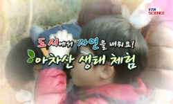
한강일대 고구려의 유적은 아차산 일대 보루군이 대표적으로, 현재 17개소의 보루가 사적 제455호로 지정되어 관리 받고 있다. 하지만 비교적 짧은 점유기간과 백제의 왕성이 위치하고 있는 지정학적 특징으로 인해 과거에는 백제와 관련된 관방유적 정도로 인식되어 있었으며, 유적에 대한 관심도 또한 매우 낮았다.
아차산 일대 성곽에 대한 최초 기록은 조선 후기에 간행된 대동지지에 아차산고성 등으로 확인되나, 본격적인 기록은 일제강점기부터 이다. 당시 비교적 자세한 유적의 위치가 기록 되었음에도 불구하고 자료는 조선총독부 내부자료로 일반인에게 공개되지 않아 해방 이후 연구에 널리 이용되지 못했다. 하지만 80년대 몽촌토성에서 고구려 토기의 존재가 확인되고 이전에 조사된 구의동 유적이 고구려 요새로 재고찰이 이루어짐에 따라, 한강 유역에서 고구려 유적에 대한 존재가 새롭게 인지되었다.
1994년 시작된 학술조사 이후로 여러 보루들에 대한 성벽과 내부시설에 대한 전면적인 발굴성과가 많이 추가되면서, 고구려 보루의 구조와 성격에 대한 다양한 연구가 이루어지게 되었다. 남한지역의 고구려 성곽의 가장 큰 특징은 일부 평지에 조성된 성을 제외하면 대부분 둘레 300m 내외로 산 정상부에 소규모로 이루어졌으며, 산 정상부에 석축을 두르고 내부 평탄지에 건물지와 저수시설 등과 같은 시설을 설치한 형태이다. 성벽은 대부분 토축부와 석축부로 구분이 되어지는데, 국내성과 장수산성에서 보이는 고구려의 전형적인 성곽 축조 수법이다. 다만 축조방법에 대해서는 현재까지 다양한 의견이 있는데, 앞으로 발굴조사와 연구가 더욱 진행되어야할 부분이다. 또한 한강유역 보루의 점유시기에 관해서는 6세기 초에서 중반까지는 대체로 이견이 없으나, 연구자에 따라 7세기 초 무렵까지 점유가 이루어졌던 것으로 파악되기도 한다. 보루는 관방시설이 가지는 기본적인 기능 이외에도 ‘官’으로서 기능도 수행한 것으로 보이는데, 비록 신라와 백제에 의해 좌절 되었으나 고구려가 이 지역을 영역지배로 하려는 의도로 보인다.
한강일대 고구려의 유적은 아차산 일대 보루군이 대표적으로, 현재 17개소의 보루가 사적 제455호로 지정되어 관리 받고 있다. 하지만 비교적 짧은 점유기간과 백제의 왕성이 위치하고 있는 ...
한강일대 고구려의 유적은 아차산 일대 보루군이 대표적으로, 현재 17개소의 보루가 사적 제455호로 지정되어 관리 받고 있다. 하지만 비교적 짧은 점유기간과 백제의 왕성이 위치하고 있는 지정학적 특징으로 인해 과거에는 백제와 관련된 관방유적 정도로 인식되어 있었으며, 유적에 대한 관심도 또한 매우 낮았다.
아차산 일대 성곽에 대한 최초 기록은 조선 후기에 간행된 대동지지에 아차산고성 등으로 확인되나, 본격적인 기록은 일제강점기부터 이다. 당시 비교적 자세한 유적의 위치가 기록 되었음에도 불구하고 자료는 조선총독부 내부자료로 일반인에게 공개되지 않아 해방 이후 연구에 널리 이용되지 못했다. 하지만 80년대 몽촌토성에서 고구려 토기의 존재가 확인되고 이전에 조사된 구의동 유적이 고구려 요새로 재고찰이 이루어짐에 따라, 한강 유역에서 고구려 유적에 대한 존재가 새롭게 인지되었다.
1994년 시작된 학술조사 이후로 여러 보루들에 대한 성벽과 내부시설에 대한 전면적인 발굴성과가 많이 추가되면서, 고구려 보루의 구조와 성격에 대한 다양한 연구가 이루어지게 되었다. 남한지역의 고구려 성곽의 가장 큰 특징은 일부 평지에 조성된 성을 제외하면 대부분 둘레 300m 내외로 산 정상부에 소규모로 이루어졌으며, 산 정상부에 석축을 두르고 내부 평탄지에 건물지와 저수시설 등과 같은 시설을 설치한 형태이다. 성벽은 대부분 토축부와 석축부로 구분이 되어지는데, 국내성과 장수산성에서 보이는 고구려의 전형적인 성곽 축조 수법이다. 다만 축조방법에 대해서는 현재까지 다양한 의견이 있는데, 앞으로 발굴조사와 연구가 더욱 진행되어야할 부분이다. 또한 한강유역 보루의 점유시기에 관해서는 6세기 초에서 중반까지는 대체로 이견이 없으나, 연구자에 따라 7세기 초 무렵까지 점유가 이루어졌던 것으로 파악되기도 한다. 보루는 관방시설이 가지는 기본적인 기능 이외에도 ‘官’으로서 기능도 수행한 것으로 보이는데, 비록 신라와 백제에 의해 좌절 되었으나 고구려가 이 지역을 영역지배로 하려는 의도로 보인다.
참고문헌 (Reference)
1 한국토지주택공사 토지주택박물관, "漣川 瓠蘆古壘Ⅳ (第3·4次 發掘調査報告書)" 2014
2 한국토지공사 토지박물관, "漣川 瓠蘆古壘Ⅲ (第2次 發掘調査報告書)" 2007
3 한국토지공사 토지박물관, "漣川 瓠蘆古壘 (精密地表調査報告書)" 1999
4 안성현, "홍련봉 1․2보루의 축조방식과 구조에 대한 연구" 백제문화연구소 (55) : 115-144, 2016
5 한국고고환경연구소, "홍련봉 1·2보루" 2015
6 윤성호, "일제강점기 고적조사 자료와 아차산 일대 고구려 보루군" 서울역사편찬원 (96) : 49-92, 2017
7 한양대학교 문화재연구소, "연천 전곡리성 – 전곡선사박물관건립부지 내 문화재 발굴조사 보고서" 2010
8 단국대학교 매장문화재연구소, "연천 은대리성 지표 및 시·발굴조사 보고서" 2004
9 서울大學校博物館, "연천 무등리 2보루" 2015
10 서울大學校博物館, "연천 무등리 1보루 정밀 발굴조사 학술자문회의 자료집"
11 경기도박물관, "연천 당포성Ⅱ - 시굴조사 보고서-" 2008
12 육군사관학교 화랑대연구소, "연천 당포성 1차 발굴조사 보고서" 2006
13 한국토지공사 토지박물관, 양주시, "양주시의 역사와 문화유적" 1998
14 서울大學校博物館, "양주 천보산 2보루" 2014
15 기남문화재연구원, "안성 도기동 유적 발굴조사 현장설명회 자료"
16 구리시, "아차산의 역사와 문화유산" 1994
17 서울大學校博物館, "아차산 제4보루-발굴조사 종합보고서" 2000
18 서울大學校博物館, "아차산 시루봉 보루-발굴조사 종합보고서-" 2002
19 최종택, "아차산 보루와 고구려 남진경영" 서경출판사 2013
20 김영섭, "아차산 고구려 보루군의 재고찰" 단국대학교 대학원 2009
21 국립문화재연구소, "아차산 4보루 발굴조사보고서" 2009
22 서울大學校博物館, "시루봉보루Ⅱ" 2013
23 양시은, "서울지역 고구려 보루 유적의 조사 성과와 과제, 서울지역 고중세 성곽유적에 대한 주요 조사연구 성과와 과제" 2017
24 문화재관리국, "서울長城 遺蹟調査 槪略報告書" 1990
25 서울大學校博物館, "부록 5 전곡리토성 시굴조사 보고서, 연천 무등리 2보루" 2015
26 심광주, "남한지역의 고구려 유적" 고구려연구회 12 : 2002
27 이형호, "남한지역 출토 고구려토기 연구" 고려대학교 2014
28 노태돈, "고구려의 한성 지역 병탄과 그 지배 양태" 서울特別史編纂委員會 66 : 2004
29 임기환, "고구려 신라의 한강 유역 경영과 서울" 서울학연구소 (18) : 1-33, 2002
30 양시은, "고구려 성 연구" 진인진 2016
31 최종택, "고고자료를 통해 본 웅진도읍기 한강유역 영유설 재고" 백제연구소 (47) : 127-160, 2008
32 서울大學校博物館, "경기도 전곡 선사박물관 건립부지 발굴조사 보고서" 2007
33 서울大學校博物館, "龍馬山 第2堡壘 發掘調査報告書" 2009
34 華陽地區發掘調査團, "華陽地區 遺蹟發掘 調査報告" 1997
35 高麗大學校 考古環境硏究所, "紅蓮峰 第2堡壘-發掘調査報告書-" 2007
36 高麗大學校 考古環境硏究所, "紅蓮峰 第1堡壘-發掘調査報告書-" 2007
37 심광주, "淸州 父母山城과 周邊 堡壘의 築城技法" 24 : 2013
38 중원문화재연구원, "淸原I.C∼芙容 間 道路工事區間內 淸原 南城谷 高句麗遺蹟" 2008
39 충북대학교박물관, "淸原 南城谷 高句麗遺蹟" 2004
40 林炳泰, "李弘稙博士 回甲紀念 韓國史學論叢" 1969
41 高麗大學校 考古環境硏究所, "峨嵯山 第3堡壘-發掘調査報告書-" 2007
42 충청문화재연구원, "大田 月平洞山城" 2003
43 서울大學校博物館, "夢村土成-西南地區發掘調査報告" 1989
44 서울大學校博物館, "夢村土成-東南地區發掘調査報告" 1988
45 서울大學校博物館, "夢村土成-東北地區發掘調査報告" 1887
46 陸軍士官學校 陸軍博物館, "京畿道 漣川郡 軍事遺蹟 地表調査報告書" 1995
47 陸軍士官學校 陸軍博物館, "京畿道 坡州郡 軍事遺蹟 地表調査報告書" 1994
48 서울大學校博物館, "九宜洞-토기류에 대한 고찰" 1993
49 이정범, "5~6세기 고구려의 한강유역 지배형태" 고구려발해학회 51 : 73-100, 2015
동일학술지(권/호) 다른 논문
-
역사적 관점에서 살펴 본 북한 『군 엘리트』의 위상 변화 - 당 정치국과 당 중앙위원회를 중심으로 -
- 국방부군사편찬연구소
- 이흥석
- 2019
- KCI등재
-
청일전쟁과 고승호(高陞號)사건의 국제법(1894-1903)
- 국방부군사편찬연구소
- 최덕규
- 2019
- KCI등재
-
- 국방부군사편찬연구소
- 윤현진
- 2019
- KCI등재
-
공군의 클라우제비츠와 머핸 찾기: 전간기 영국공군참모대학의 군사사 교육
- 국방부군사편찬연구소
- 이상현
- 2019
- KCI등재
분석정보
인용정보 인용지수 설명보기
학술지 이력
| 연월일 | 이력구분 | 이력상세 | 등재구분 |
|---|---|---|---|
| 2027 | 평가예정 | 재인증평가 신청대상 (재인증) | |
| 2021-01-01 | 평가 | 등재학술지 유지 (재인증) | |
| 2018-01-01 | 평가 | 등재학술지 유지 (등재유지) | |
| 2017-10-23 | 학회명변경 | 영문명 : 미등록 -> Military History Institute, MND | |
| 2015-01-01 | 평가 | 등재학술지 유지 (등재유지) | |
| 2011-01-01 | 평가 | 등재학술지 유지 (등재유지) | |
| 2008-01-01 | 평가 | 등재학술지 선정 (등재후보2차) | |
| 2007-01-01 | 평가 | 등재후보 1차 PASS (등재후보1차) |  |
| 2006-06-29 | 학술지명변경 | 외국어명 : 미등록 -> military history | |
| 2006-01-01 | 평가 | 등재후보학술지 유지 (등재후보1차) | |
| 2004-01-01 | 평가 | 등재후보학술지 선정 (신규평가) | |
학술지 인용정보
| 기준연도 | WOS-KCI 통합IF(2년) | KCIF(2년) | KCIF(3년) |
|---|---|---|---|
| 2016 | 0.69 | 0.69 | 0.62 |
| KCIF(4년) | KCIF(5년) | 중심성지수(3년) | 즉시성지수 |
| 0.63 | 0.6 | 1.024 | 0.34 |
이 자료와 함께 이용한 RISS 자료
나만을 위한 추천자료


